Entangled Milieus for the Commons of the Soled/ Lefka Valley in Federal Cyprus
Tutors: Socrates Stratis, Melina Philippou, Charis Nika
2022-23
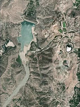
The urban design studio of the Department of Architecture, University of Cyprus, explores the constitution of the Commons that will support rural living, in a reunified island of Federal Cyprus. The countryside, based on this investigation, is organized as a network of micro-cities that are part of extended ecosystems where human and non-human factors have equal participation in shaping their common future. The studio will examine the negative implications on the landscape from the processes of natural resource extraction and energy production, from the organization of space for agricultural activities and food production, as well as from the continuous expansion of built-up areas. The concepts of “entanglement” and “de-growth” acquire a central role in the design process. The studio’s field study is the area along the rivers Karkotis and Xeros that run along the northern slope of Troodos and end up in the Gulf of Morphou passing through the United Nations cease fire zone. Part of the field study area is located in the northern part of the island controlled by Turkey after the 1974 invasion, which followed the military coup organized by Greece. The studio will investigate the effects of mining waste from the region’s mines covering significant areas, the role of irrigation rights and the power relations they shape, the fragmentation of land due to the expansion of human activities, as well as the negative effects of the presence of the dividing line. The studio is part of the international conference entitled “Entangled Milieus: co-constituting a shared futurity”. It is organized by the
Research Centers of LUCY, Department of Architecture of University of Cyprus, and of the “Borders and Territories” of Delft University of Technology, the Netherlands (TU Delft) together with the School of Architecture of the University of Sheffield, United Kingdom. https://www.entangledmilieus.com/


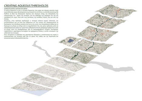
Creating Water Thresholds
Team: Constantinos Papanicolaou, Despina Panayiotou, Margarita Grouta, Payiota Kyriakou
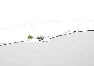
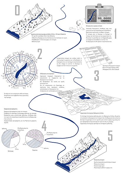
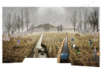
“Creating Water Thresholds” investigates how Karkotis river becomes an entity with its rights instead of being a resource for human exploitation. The first step for the project is to map the still-in-use ancient water channel network that spreads along the Solea valley, which is disrupted by the United Nations Cease fire line. It maps the new water infrastructures, including the Solea water damn, that cause decreased water quantities in the river’s bed and the north part of the island. Furthermore, the project includes the documentation of the conflicts that occur due to water distribution disputes. As a second step, the “Creating Water Thresholds” project redesigns the water channel network to serve the river’s rights and equal water distribution in the nearby villages. The project reformulates the year program of water rights to create a period for the river’s rights and proposes to stop channelling water to Solea damn. On specific days the water may run freely along its bed without being used by humans, but only by more than human entities. The water channel beds are conditioned to allow for the water to enrich small pools and the soil.


Let it Bee
Team: Anastasia Spyrou, Evaggelia Ioannou, Nicoletta Vitti, Styliani Ioakeim
The “Let it Bee” project recognizes and promotes the importance of bees and pollination for regenerating the natural ecosystems of the damaged area caused by past copper mining activities. The project formulates a series of strategies for creating an open system of interventions in critical areas of the northern part of the Solea and Lefka valleys. The interventions include the creation of ecological corridors for the bees to traverse the waste dump sites safely and sustain their pollination in the valley. The ecological corridors expand yearly to decrease the polluted sites. Furthermore, the strategies involve the creation of ecological islands in the built-up areas of the valleys and systematically observing the bee population in the area. To implement the strategies, the project team designs guides and manuals to involve actors and institutions under the Federal State of Cyprus, organized environmental groups, beekeepers and farmers, and volunteer university students.


Cultivating & Collectivity
Team: Anna Maria Ioannou, Georgia Nicolaou, Katerina Pavlou, Rafael Sarmallis
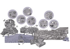
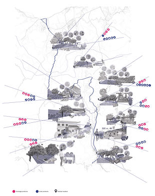
The “Cultivating & Collectivity” project builds on the aim of the UCY Urban Design studio to support the commons of the Solea valley countryside in Troodos Mountain, with the scenario of the reunification of the island as a Federal State. The project investigates the commons that relate to the food production cycle of the area. It aims to form a food production network through the existing festivals that the project team has carefully mapped. The “Cultivating & Collectivity” project involves strategies that improve the existing food production network and promote collectivity among the various villages of the area through the creation of broader food production-based communities. The strategies are about the inter-local strengthening of rural development and product economy through the exchange at the festivals. It is also about the spatial organization of the community spaces at hand. The “Cultivating & Collectivity” project involves a carefully designed timetable and toolbox for activating existing and new festivals that occur throughout the year. The project team designed a manual where the strategies are showcased to be handy to the farmers and festival actors of the area.
_edited.jpg)


Trans-Solea Network
Team: David Pereira, Gogo Savvidou, Panayiotis Anastasiou,
The “Trans-Solea Network” project investigates how a public mobility network with its centralities serves the Solea and Lefka valleys by substituting private car use and sustaining the reunification of Cyprus. The mobility network connects existing natural trails and local roads with trans-local and local bus lines. It facilitates the inhabitants and visitors to move freely from the mountainous Kakopetria village to the coastal area of Karavostasi and vice-versa by combining modes of soft mobility. The network comprises three primary nodes and many smaller ones. The primary nodes offer new proximities of public programs accessible to the region’s inhabitants. The readjustment of a high school’s open space in Evrychou, an open space by the sea in Karavostasi, and an existing bus station in Kakopetria support the network’s primary transport nodes. The smaller nodes are in the villages’ central squares and facilitate the interaction of the inhabitants with the passers-by.


Connecting by Cleaning
Team: Eleftheria Vasiliou, Florentia Vardaki, Michalis Fountoulis, Michelle Touastat
The “Connecting by Gleaning” project investigates food production and waste at the Solea and Lefka valleys. It proposes to reduce food waste by promoting a post-seasonal collective fruit and vegetable picking, a sort of designed gleaning. For that reason, the project involves the design of a temporal commons’ territory that expands into zones of private orchards and fields just after the official picking of agricultural products. The accessibility of the general public into these areas is carefully designed by promoting light infrastructures for accessing, storing and exchanging goods. Reusing empty house ground floors, parking lots, military storages, and school fields creates a network of collective spaces that may trigger sociability among the valleys’ inhabitants who are currently separated by the UN Cease-Fire zone.


A Walk on Train Tracks
Team: Fivos Tsaggaras, Kyriaki Koliandri, Maria Kyriakou, Pany Siampi,
Victoras Pilavas, Violette Pandolfi
The “Walk on Train Tracks” project investigates the territorial impact of the pollution caused by the mining infrastructures of the Solea Valley, and it proposes actions in a short and long-term timeline to inform the broader public and promote restoration processes. The extraction industry of the mineral wealth in the valley has irreversibly damaged the areas of Karavostasi, Xeros, Foukasa, Mavrovouni and Apliki due to tailings dumping and the creation of large mountain pits. These areas’ pollution is due to the concentration of heavy metals and other highly polluting elements. The air, soil and water contamination threaten the health of the area’s inhabitants, animals, and plants and all of Cyprus. Considering this, the project formulates the following strategies. The first strategy is to connect the areas that suffer from past mining activities through a 40km long hiking route that follows mostly the forgotten tracks of the old industrial railway. This loop hiking route aims to encourage Cypriots and visitors to experience the damaged landscape and become aware of the pollution impact. The second strategy is restoring the polluted areas of Karavostasi, Xeros, Skouriotissa and the Lefka dumpsite by covering with geotextile the surfaces that generate polluted dust, creating natural barriers to polluted water flows and by absorbing soil polluting thanks to phytoremediation. The third strategy is reusing the former mining infrastructure by introducing human activities within the Karavostasi, Xeros and Skouriotissa.